


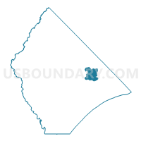
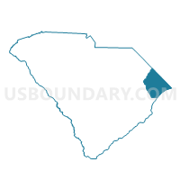
Leon Voting District, Horry County, South Carolina
About
Outline

Summary
| Unique Area Identifier | 666072 |
| Name | Leon Voting District |
| County | Horry County |
| State | South Carolina |
| Area (square miles) | 18.86 |
| Land Area (square miles) | 18.83 |
| Water Area (square miles) | 0.03 |
| % of Land Area | 99.82 |
| % of Water Area | 0.18 |
| Latitude of the Internal Point | 33.91546890 |
| Longtitude of the Internal Point | -78.77446600 |
Maps

Graphs
Select a template below for downloading or customizing gragh for Leon Voting District, Horry County, South Carolina


Neighbors
Neighoring Voting District (by Name) Neighboring Voting District on the Map
- Dogwood Voting District, Horry County, SC
- Ebenezer Voting District, Horry County, SC
- Mt. Vernon Voting District, Horry County, SC
- Nixon's Cross Roads 1 Voting District, Horry County, SC
- Red Bluff Voting District, Horry County, SC
- Wampee Voting District, Horry County, SC
Top 10 Neighboring County Subdivision (by Population) Neighboring County Subdivision on the Map
- Conway East CCD, Horry County, SC (65,364)
- Little River CCD, Horry County, SC (33,652)
- Longs CCD, Horry County, SC (6,645)
Top 10 Neighboring Unified School District (by Population) Neighboring Unified School District on the Map
Top 10 Neighboring State Legislative District Lower Chamber (by Population) Neighboring State Legislative District Lower Chamber on the Map
Top 10 Neighboring State Legislative District Upper Chamber (by Population) Neighboring State Legislative District Upper Chamber on the Map
Top 10 Neighboring 111th Congressional District (by Population) Neighboring 111th Congressional District on the Map
Top 10 Neighboring Census Tract (by Population) Neighboring Census Tract on the Map
- Census Tract 401.01, Horry County, SC (4,626)
- Census Tract 603.01, Horry County, SC (3,236)
- Census Tract 301.03, Horry County, SC (3,116)
- Census Tract 301.02, Horry County, SC (2,789)